Warning: mysql_result(): state not found in MySQL result index 3 in /home/leagan1/ericandleandra.com/waterfalls_admin/waterfall_page_creator.php on line 51
upper Little River Falls
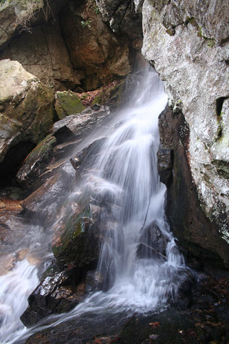
photo taken 3/25/2007
Location: North Carolina
Directions: This waterfall can be accessed from South Mountains State Park. Take exit 105 off I-40 and head south on NC 18. Drive 10.7 miles to SR 1913 (Sugarloaf Road), turn right. Continue for 4 miles until the road deadends into SR 1924 (Old NC 18) and turn left. Travel 2.6 miles to SR 1901 (Ward's Gap Road) and turn right and go 1.3 miles to SR 1904, then turn right. The park is 3.5 miles up the road. (This may sound confusing, but thankfully there are signs for the park at every turn.) Park in the Cicero Branch parking area on the left and cross the street to pick up the Little River Trail about 0.2 miles up the road. After a long and difficult (mostly uphill) climb of two miles, you will reach a fence with a warning sign to go no further. Technically, this waterfall is just outside the boundary of the park. You will be able to hear the waterfall at this point, but it's quite a climb down and you can only see this waterfall from the side. We don't recommend it because of dangerous conditions, but if you climb even further downstream, you will see the lower part of Little Creek Falls.
GPS: 35.609546,-81.610265 (approx.)
Other waterfalls nearby: lower Little River Falls